
Canelones opens 500 metres of pedestrian seafront path in Parque del Plata and announces an extension to Atlántida
The first stretch opened on 13 October 2026. The rest, through Las Toscas to Atlántida, is to include a bike path. Beyond those 500 metres nothing has a design yet.
On 13 October 2026 the head of the Canelones departmental government, intendente Francisco Legnani, cut the ribbon on about 500 metres of concrete path along the seafront of Parque del Plata, a beach town on the Costa de Oro east of Montevideo, and said it was the start of something longer: a pedestrian seafront path that will run from the Arroyo Solís Chico, the stream at the town's eastern edge, through the neighbouring town of Las Toscas to Atlántida.1 The department's own name for the project is a paseo costero peatonal, a pedestrian seafront promenade, and that is the first thing to be clear about.
Two words, read carefully. "Pedestrian" is the official word, in the headline and in the description of what was built: a walkway, with new drainage beneath it, reworked driveway crossings and public furniture, on the inland side of the road so as not to touch the dunes.1 "Bike path" is the intendente's word. At a press conference on the spot, Legnani said the connection between Atlántida and the Solís Chico would be made with a bike path and a pedestrian passage, a bicisenda and a pasaje peatonal, in the department's own paraphrase.1 The first exists; the second is, so far, a stated intention. Nothing in the official description marks the finished stretch for bicycles, and the sources consulted do not say whether a bicycle may use it.
What a visitor can ride today is the road. Atlántida, Las Toscas and Parque del Plata share a seafront avenue that changes its name town by town, Rambla Tomás Berreta, Rambla Alfredo Zitarrosa, Rambla Lumen Martínez Burlé, running about a hundred metres back from the beach with ordinary mixed traffic. OpenStreetMap records no cycle lane or bike path along the seafront road.3 For scale, and only as a map figure, the seafront road from Atlántida to the eastern end of the Parque del Plata rambla measures a little over five kilometres on OpenStreetMap.3
Money and calendar. The built stretch cost an estimated 12.6 million Uruguayan pesos, paid from departmental funds, with the contractor Wajery S.A.1 For everything beyond it there is no published cost, no length and no design. Legnani said completing the link "will take significant work" and that he hopes to have it finished before the end of the current term of office.1 The newspaper El Observador, citing the department's secretary general, Pedro Irigoin, reported that tendering is expected to begin in February, with one stage of work over a winter and another in 2028;2 the department's release gave no dates.
The dune side and the road side. The geography explains the one design decision that has been made. In Parque del Plata the strip between the rambla and the sea is dunes, so the path went on the inland side of the road. The mayor of the Parque del Plata–Las Toscas municipality, Tania Vecchio, said the extension toward Atlántida will keep to that inland side, and that Las Toscas, which has a little more room toward the beach, will follow the same rule.1 That is the whole of the published alignment, and the map on this page draws it as announced, dashed, with no fixed end in Atlántida.
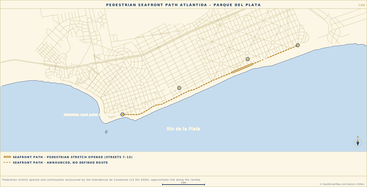
Key
The thing to watch is the tender. Further west along this coast, the Ciudad de la Costa seafront path took almost eleven years to grow from a first kilometre in 2015 to nearly thirteen kilometres in 2025, and it had a bike lane from its first stretch. This one begins as a walkway with a bike path announced. If a tender appears in February, the documents will say which of the two it is.
- Intendencia de Canelones. Parque del Plata, Las Toscas y Atlántida quedarán conectados con paseo costero peatonal. imcanelones.gub.uy, 14 Oct 2026.Accessed 29 · OCT · 2026
- El Observador. La Intendencia de Canelones construirá un paseo costero que unirá Parque del Plata, Las Toscas y Atlántida. elobservador.com.uy, 15 Oct 2026 (subscriber article).Accessed 29 · OCT · 2026
- OpenStreetMap contributors. Data for the Atlántida–Parque del Plata coastal strip, Overpass API query on the 20 Oct 2026 database (cycleways, seafront roads, coastline); Rambla Lumen Martínez Burlé: openstreetmap.org/way/341672903.Accessed 29 · OCT · 2026