Coastal Utopias —
a ride along the shore
A bike itinerary between Carrasco and Neptunia that traces how the Uruguayan coast was imagined, reshaped, and inhabited through a succession of utopias.
This itinerary grows out of a personal experience and a present-day situation along Uruguay's coast. After several years living in Germany — where family cycling and unhurried, healthy leisure are an everyday part of life — I arrived in Uruguay ten years ago with that sensibility already in me. The recent completion of the final stretch of the Ciudad de la Costa bike path opened up, for the first time, the kind of riding we had taken for granted in Germany: a continuous route, accessible and safe for every age.
Choosing the day matters more than it seems. Experience taught me to weigh the direction of the wind — a decisive force on the Río de la Plata shore — and to avoid the hottest days and the rain. Even so, the route stays forgiving, because all along it there are places to stop, cool off, and rest: small shops and seafront kiosks, the deep shade of the Parque Roosevelt woods, the coastal pine stands.
A bicycle sits at exactly the right scale for reading a landscape. Slower than a car and faster than walking, it lets you register vegetation and urban form while still allowing you to stop, turn aside, and pick the route back up without losing the thread. Movement itself becomes a way of understanding spatial transitions that other speeds pass straight over.
The study pairs fieldwork — looking closely, on the ground — with historical and territorial research, so the coast can be read as a cultural landscape.
The itinerary is built around a series of landscape singularities. They are marked as points of observation, but each belongs to longer stretches, where the experience of the landscape is made in motion and over time. Together they let you read the coast as a continuous sequence of landscapes and ways of living.
At that meeting point — between the experience of the ride and the reading of the landscape — the itinerary becomes a tool for noticing how the coast between Carrasco and Neptunia has been imagined and transformed through different coastal utopias. In each historical moment, nature was understood and treated differently — as stage set, as technical problem, as the ground of everyday life, or as a system to conserve — steering the decisions, projects, and interventions that settle into the territory and shape the cultural landscape we have now.
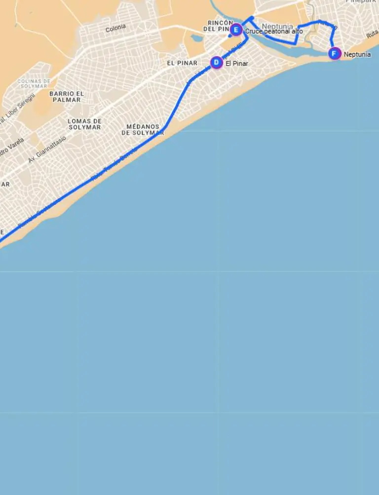
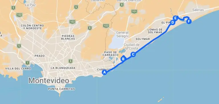
Map of the itinerary
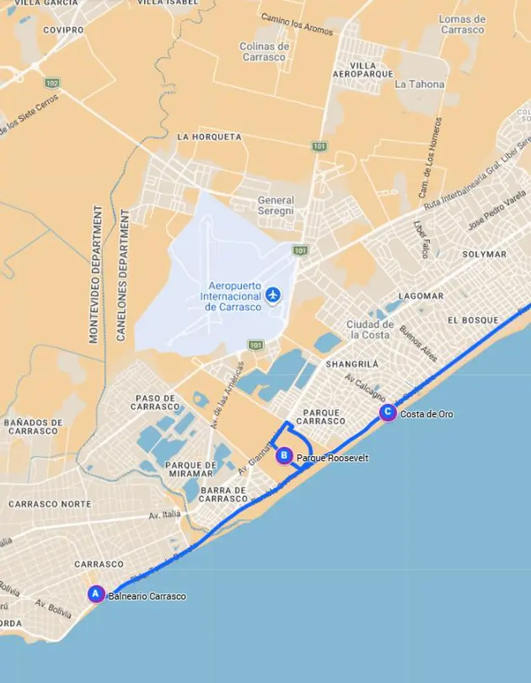
Balneario Carrasco
The vanguard of the faraway
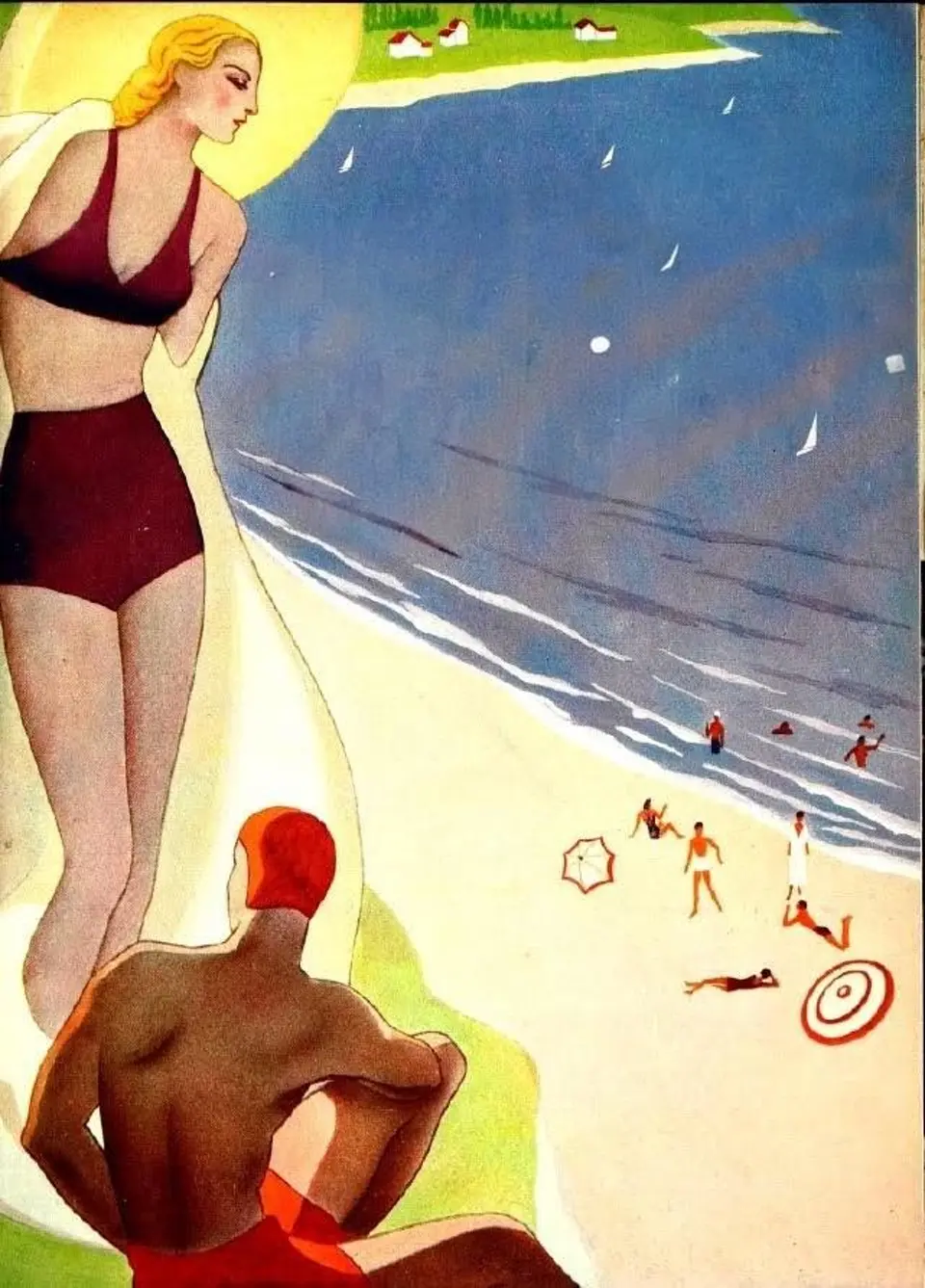
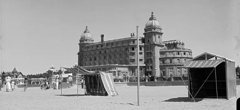
Picture yourself in an aristocratic family of 1930s Montevideo. Sea bathing has become a modern, healthful practice, but the beaches you can reach by tram no longer confer any distinction. Carrasco, by contrast, offers distance and exclusivity.
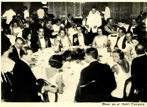
Getting there is deliberately hard: you come by the high roads, following the Camino Carrasco along the ridge, skirting the long coastal sand flats. The journey is part of the ritual. Once there, the winding layout of the balneario — this seaside resort district, conceived in 1912 as part of a landscape plan by the French landscape architect Charles Thays — lined with avenues of maritime pines, leads you down toward the beaches and the sea.
Carrasco is not only rest: it is display. Dressing for the evening, walking the streets, taking a drink at the casino. The landscape works as a carefully built social stage. From here the itinerary dissolves into the continuity of the rambla, the waterfront road and walk that runs the length of the shore, carrying you on toward the next singularity.
Parque Roosevelt
Dominion over nature
The way of seeing changes as you roll into the Parque Roosevelt. This is no longer distinguished leisure, nor landscape as social stage. From the viewpoint of engineers and agronomists like Carlos Racine, the problem is above all material: vast wetlands, shifting sand, and unstable soils that ruled out any kind of settlement.
The project became possible through the donation to the State, in 1907, of the lands belonging to the family of don Doroteo García. This gift of 1,300 hectares was conditioned on draining 100 hectares of bañado — marshland — to reduce public-health risks, and on afforesting 300 hectares for a public park.
Within that framework, in 1916 the State created what was then the Parque Nacional de Carrasco — Uruguay's first state park — and charged Racine with designing and carrying out large-scale afforestation. The technical answer was clear and radical: plant a great deal, plant densely, plant fast. Within a few years some 700,000 trees went in, mostly eucalyptus, maritime pines, and acacias, chosen for quick growth and hardiness.
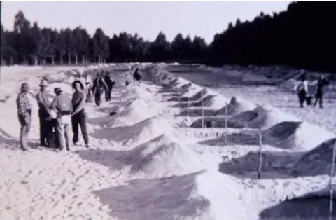
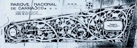
The high planting density was not an ornamental choice but a logic of territorial infrastructure, true to a forestry policy the State pushed at the start of the twentieth century. The utopia here is not escape or fantasy but progress: to master nature and make it useful, productive, shared.
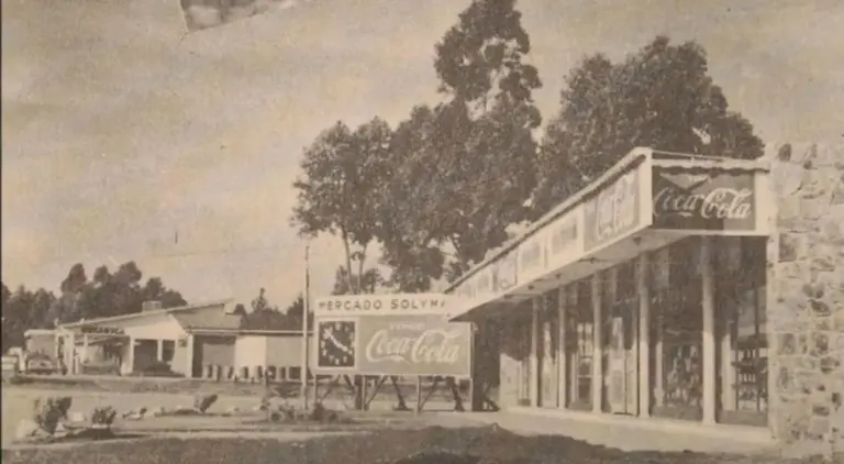
Costa de Oro
From sand flat to suburb
Leaving the unbroken shade of the Parque Roosevelt, the landscape opens and shifts register. The experience stops being immersive and arranges itself into bands, always over a sandy substrate that governs the ground. The bike rolls past a line of young pindó palms, still low and even. To one side, a drainage ditch keeps pace with the route and turns into a green corridor where giant reed, lantana, castor bean, hopbush, acacia, and morning glory appear.
Toward the coastal edge the vegetation grows lower and patchier. The psammophilous belt arrives — the plants adapted to sand, wind, and salt — acting as a transition between worked soil and beach. Along this edge, here and there, stand clusters of maritime pines bent by the steady work of the wind, marking direct exposure to the sea and recalling how unstable the ground still is.
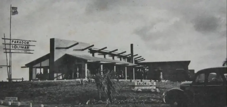
On the opposite side, the road and its shifting façades — adapted summer houses, new construction — announce the definitive entry into the Ciudad de la Costa. This stretch is defined not by any single point but by the riding itself. The singularity is in the slow movement, in watching the urban eclecticism of the façades. The old summer house — light, built of flagstone, made for the season — adapts step by step to other uses. A school set up inside a holiday house reads as a clear sign: people no longer come here only to spend the summer; they live here all year.
The Costa de Oro expresses a domestic utopia, where the landscape stops being stage or infrastructure and becomes the ground of everyday life.
The car shortens distances and changes the bond with the coast. Arriving stops being an exceptional outing and becomes routine. In that passage — sand flat, balneario, suburb — you can see how the wish to escape the city ends, inevitably, by producing another city.
El Pinar
The sensory escape
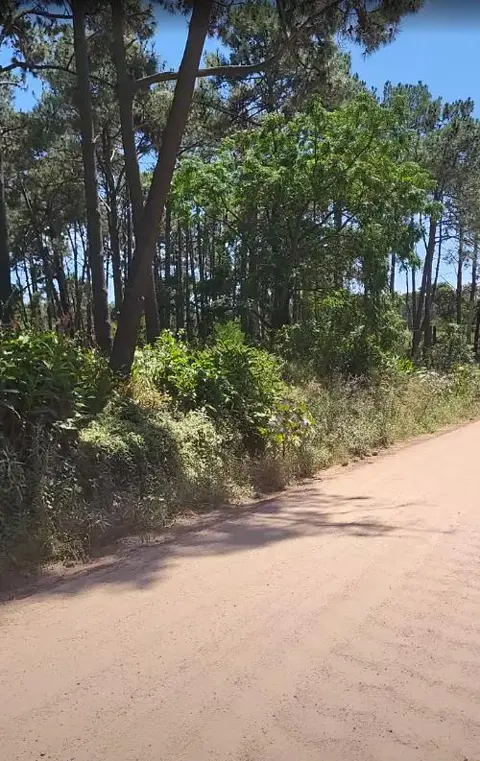
Entering El Pinar lets you read, almost as a territorial memory, what the Costa de Oro was when it was still a balneario. It is not a fixed point but a stretch you ride through. The gravel streets force you to slow. The bike falls into that rhythm and tunes the scale back to the body. As you draw away from the shoreline the sensory experience deepens: a near-unbroken planting of maritime pines, set between both lanes of the street, makes a permanent corridor of shade.
Here the pinewood is felt not as exceptional scenery but as a learned, familiar setting, built from the lingering smell of resin and the loose needles underfoot.
This planted wood sits, as everywhere on the coast, on a sand flat that did not vanish but was tamed. Under the needles the fixed sand persists, a reminder that today's landscape is the result of a long operation on unstable ground. The maritime pines, brought in to fix the dunes and make the soil livable, ended up woven into the everyday imagination of the summer and of coastal life — more present to the senses than many native species.
Here the landscape keeps a tolerant structure, where what was planted lives alongside spontaneous regrowth and daily use. The singularity lies in the slow movement, in the continuity of the shade, in the kept gardens glimpsed sideways over low fences, never breaking the reading of the wood. There is no closed form, no rigid design: the sand flat persists beneath the planting and resurfaces at the edges, recalling how unstable the ground is.
El Pinar appears, then, as one of the last stretches of the itinerary where the body still organizes the experience of the territory — before the logic of infrastructure takes over.
The high pedestrian crossing
The reign of the car
The landscape breaks off abruptly at the overpass crossing the Ruta Interbalnearia — the fast coastal highway that strings the resort towns together. The infrastructure organizes large-scale flows on a mainly vehicular logic. Vegetation is reduced to margins and embankments, a residual accompaniment to the road. Though the path lifts above the cars, the body stops being the measure of the space. On foot or by bike, the crossing stays indirect, long, and alien. The territory is connected, but not continued.
This point expresses a wider transformation of the coastal corridor. The Interbalnearia stopped working as a fast route and became, through the density of the resorts, a metropolitan avenue. The infrastructure, though, answers that change late. The result is a road that combines the traits of a street and a road without resolving either — what contemporary urbanism calls a stroad.
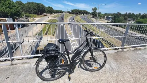
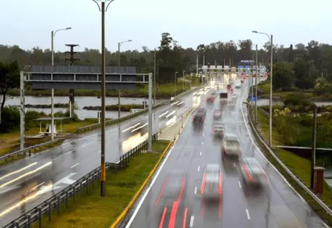
In this logic, the priority is to keep the car flowing. The scale is set to be read at speed, and pedestrian and cyclist are pushed off onto technical fixes that build no urban continuity. The raised crossing works as a barrier: it severs fabrics, lengthens everyday journeys, and turns the act of crossing into an exception within daily life. The neighbour who lived "across the way" ends up living kilometres away — because the crossing is dangerous, or because it demands an exhausting detour.
To reach the next singularity you have to cross a bridge with no footway or bike lane, narrow and uncomfortable, set just before the toll. The body is left exposed, pressed between fast lanes, railings, and noise. The interchange appears, then, as a fracture inside the itinerary. The landscape is still there on both sides, but it stops articulating the route. The infrastructure redefines how you can be in the territory — just before, leaving this system behind, the landscape opens again.
Neptunia
Living with the unstable
At Neptunia the landscape is no longer organized by the fixing of sand or by infrastructure, but by the dynamics of the estuarine edge. Along the coastal strip, native dune grasses such as pasto dibujante mix with introduced species like lion's ear to form a low, irregular, shifting border.
The nearness of the Arroyo Pando shapes this system. Along its banks a riverside woodland persists — curupí, red sarandí, ceibo, and arazá, species adapted to the alternation of fresh and salt water, to the tides and the seasons. The vegetation shields the banks from erosion and orders a territory of transition, where the limits are not fixed and the landscape recomposes itself continually.
Unlike the earlier stretches, Neptunia imposes itself neither as image nor as infrastructure. While fast traffic keeps to the Interbalnearia, this landscape is left aside, out of the way, reachable only by whoever slows down and leaves the main road. That marginal condition deepens its fragility — but also its worth.
Neptunia embodies, then, a more recent utopia: to conserve nature by accepting its instability. The landscape is neither fixed nor fully ordered; it is managed as a wild garden, where human intervention seeks to accompany open processes rather than dominate them. In that closing contrast — between the speed of the infrastructure and the slowness of the ecosystem — the itinerary finds its end: to live alongside nature is, always, to live with change.
The close of the itinerary
The itinerary can be read as a succession of attempts to escape toward nature — understood, in each historical moment, as whatever stood opposed to the city, the noise, the artificial. And yet that escape always turns out to be a utopia: each time we "arrive" at nature, we transform it. Fixing dunes, draining marshes, afforesting, laying roads, building infrastructure, consolidating settlements — all of these reshape the territory and redefine the very thing we set out to find.
Along the way it is not only the landscapes that change, but the ways of understanding and handling nature. The singularities examined here let us recognize how those conceptions worked as coastal utopias, steering concrete decisions, projects, and interventions. At Carrasco, nature is built as a representative stage; at the Parque Roosevelt, it is taken on as a technical problem to solve; at the Costa de Oro and at El Pinar, as the ground of everyday life; at the Interbalnearia interchange, it is subordinated to the logic of infrastructure; and at Neptunia, it appears as a dynamic system whose conservation means accepting instability.
The coast appears, then, not as a final destination but as a territory in permanent movement, where to inhabit is, inevitably, to inhabit change.
Read as a whole, the route shows not a successful flight toward some earlier, intact "natural" state, but a relationship in permanent redefinition between inhabiting and transforming. The coast between Carrasco and Neptunia reveals itself as a stratified cultural landscape, where different historical and territorial layers overlap, coexist, and at times pull against one another.
Botanical index
Sources consulted
- Centro de Fotografía de Montevideo (CdF). Archivo fotográfico histórico de Montevideo y la costa metropolitana. cdf.montevideo.gub.uy · Accessed 15·VI·2026
- Comisión Nacional de Turismo. Turismo en el Uruguay. Año I, Nº 1. Montevideo, 1935. anaforas.fic.edu.uy · Accessed 15·VI·2026
- Dirección Forestal (MGAP). Crónicas del desarrollo forestal del Uruguay II. Montevideo, 2007. gub.uy · Accessed 15·VI·2026
- Figueredo, Eloísa. "A la sombra de los pinos". La Diaria, Cotidiana, enero de 2024. ladiaria.com.uy · Accessed 15·VI·2026
- Intendencia de Montevideo. Habitar Montevideo: 21 miradas sobre el habitar urbano contemporáneo. 2019. academia.edu · Accessed 15·VI·2026
- López Reilly, Andrés. "Ruta Interbalnearia: proponen varios cruces bajo tierra para aliviar el tránsito". El País, 2020. elpais.com.uy · Accessed 15·VI·2026
- Michelena, Alejandro. "Don Carlos Racine". Letras Uruguay. letras-uruguay.espaciolatino.com · Accessed 15·VI·2026
- Parque Roosevelt (Intendencia de Canelones). Historia del Parque Roosevelt. parqueroosevelt.uy · Accessed 15·VI·2026
- Solymar ayer y hoy. Video documental. YouTube · Accessed 15·VI·2026
- Sociedad de Arquitectos del Uruguay. "Centenario del Hotel Carrasco". sau.org.uy · Accessed 15·VI·2026
Sources are in Spanish — the history of this coast is written largely in the language of the people who shaped it.