The rambla by bike: Montevideo from the port to Pocitos
With one day in Montevideo — off a cruise ship, say — the classic thing to do is ride the rambla, the open coastal road that traces the Río de la Plata. Rent a bike near the port, point it east, and in a relaxed half-day you have the city's most popular ride and, stop by stop, a century of its history.
Key
Sights
Practical points
Montevideo's rambla is the longest street in the city and the one everyone looks at. It runs beside the Río de la Plata — a river so wide it reads as a sea — from the Old City out to the eastern suburbs, and its central stretch, port to Pocitos, strings together most of what is worth seeing from the water's edge. Ride it and you have the postcard the city sends home: AllTrails ranks it Montevideo's most popular bike route, and it recurs in nearly every account written by someone who has pedalled it.
The shape of the ride
Plan on roughly ten kilometres from the Escollera Sarandí, the breakwater at the western end, to the giant MONTEVIDEO letters on Pocitos beach in the east. None of it is hard: the coast is flat, the wind off the river is the only real effort, and there is no reason to hurry.
The first stretch is proper cycling infrastructure. Until recently, riding the rambla meant improvising along the pavement; that changed with the city's Late la Rambla (“The Rambla Beats”) programme, unveiled in February 2024. Its 4.7-kilometre Rambla Sur bike lane, from the Escollera Sarandí to the fishing clubs at Parque Rodó, opened that September and pushed Montevideo past 77 kilometres of cycling infrastructure. Along its first section the lane tucks behind the parking row, so the parked cars sit between you and the traffic. East of the fishing clubs, toward Punta Carretas and Pocitos, you continue on a two-way path on the pavement. The joins between one stretch and the next are uneven — take the whole thing as a coast to be enjoyed at a gentle pace rather than a cycle motorway.
A coast a century in the making
The rambla was not laid down in one go. It grew in pieces across the first third of the twentieth century, carried along by two currents at once: a middle class discovering the seaside, and a reformist state, under President José Batlle y Ordóñez, determined to shape the city's growth along its own coast. (Batlle blocked a concession that would have handed the future waterfront to private owners; a 1912 building code fixed the principle that the coast was public — a matter of hygiene, beauty, and everyone's right to reach the sea.) The beach suburbs to the east came first, from around 1906. The monumental piece came later.
That piece is the Rambla Sur, the four-kilometre span from the Old City to Parque Rodó that forms the heart of this ride. Engineered by Juan P. Fabini, it was begun in 1923, stalled by a storm, redesigned, and finally opened in December 1935 — fifty metres wide, built on 70,000 cubic metres of concrete, with 800,000 square metres of sand reclaimed from the river. It is worth knowing what that cost. Nine hundred and twenty-nine plots were expropriated, and between 1928 and 1935 the shoreline district the city called El Bajo — poor and pressed against the water — was demolished, along with two beaches, Santa Ana and Patricios. The rambla you ride is both a civic triumph and the lid over what it displaced; a 1986 resolution lists it as a Cultural Historic Monument.
Stop by stop, west to east
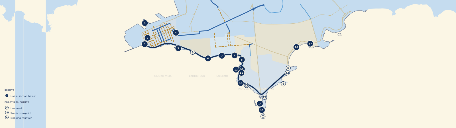
On the map above, each numbered marker opens a card, and from the card you can drop to the fuller story below. Smaller markers flag the practical things — lookouts, a drinking fountain, toilets, a playground — that don't get their own section.
Buquebus Terminal
The ride begins at the ferry terminal, where the boats to Buenos Aires and Colonia dock — for anyone crossing from Argentina, the first sight of Montevideo. The building dates from the late twentieth century and carries recognised architectural value; a private plan announced in 2025 would modernise it and rebuild the neighbouring Muelle Maciel, a pier from 1928.
The Customs House
Art Deco reached Montevideo early — early enough that the Customs House, a few minutes on, was designed before the style had a name. Jorge Herrán, one of nineteen entrants and only twenty-six years old, won its 1922 competition; the Paris exhibition that would christen “Art Deco” was still three years away. His building, finished in 1931, climbs 62 metres to a glass dome and is today a National Historic Monument. The bike lane runs along its front.
Escollera Sarandí
Where Calle Sarandí, the Old City's pedestrian spine, reaches the water, it does not stop — it runs on into the river as a stone breakwater, and this is the ride's western anchor. Walk out to the lighthouse at its tip and the river opens on either hand, the port on one side and downtown's skyline on the other; Montevideans save the walk for sunset. Adolfo Guérard engineered it in 1899, and the 22-metre light, first lit in 1909, remains a Navy charge.
Plaza Independencia
Four hundred metres inland — a short detour off the coast — the square between the Old City and downtown opens up. It stands on the footprint of the colonial Citadel, whose only surviving gate still guards one corner; the square itself was laid out in 1837. Artigas, the national hero, rides across its centre in bronze, cast in 1923 above the vault that holds his remains. The façades ringing the square read like a roll-call of the city — the Teatro Solís, the Palacio Estévez, and the slim, unmistakable silhouette of the Palacio Salvo.
Dique Mauá
East of the Customs House sits the first dry dock on the Río de la Plata, opened by the Baron of Mauá on the last day of 1872. Its grounds include the old Gas Company and an English-style clock tower from 1867, carved with the Latin motto ex fumo dare lucem — “from smoke, to give light.” Shut for decades, the site reopened in December 2025 as Parque Mauá, free to enter, with a self-guided history trail: one of the newest things to see along the whole coast.
Barrio Sur Lookout
Here the rambla runs along Barrio Sur, the birthplace of Montevideo's Afro-Uruguayan community and of candombe — the call-and-response drumming, played on three drums, that UNESCO listed as Intangible Cultural Heritage in 2009. This was the stretch most transformed by the Rambla Sur: winning the coast from the river meant erasing the neighbourhoods that once reached the water. Inland, a pedestrian street known as the “candombe walk” links the rambla to the heart of the barrio, and each summer the drum parades called Las Llamadas fill these streets. The lookout faces the river square-on, the city at its back.
The Minas Blocks
Where the rambla widens at Calle Minas, it forms one of three terraces — Fabini's “balconies over the sea.” The platform rides out over the water on huge precast concrete blocks, the very ones that raised the sea wall between 1926 and 1935 and won those 800,000 square metres from the river. Still bare to the eye, the blocks are at once an engineering feat and the surface that buried the neighbourhood below — the clearest single spot to see the rambla's grandeur and its cost holding the same ground.
Playa Ramírez
One of the city's first beaches takes its name from José Ramírez, whose salting works here was among early Montevideo's founding industries. It was a busy bathing spot long before the rambla existed; today it is quieter and more local than Pocitos, set against an unusual backdrop — Parque Rodó, the quarry walls of the open-air theatre, and the neoclassical hulk of the Engineering Faculty. Next door to the east is El Cuadrado.
El Cuadrado
Montevideans call this terrace El Cuadrado — “the square” — for its shape, though the life on it is anything but square. Another of Fabini's sea balconies, it opened with the terrace in late 1935 around a public skating rink that has run almost without a break since. Over the decades it grew into a world of its own: roller skaters, skateboarders, calisthenics bars, murals along the walls, and above all the young. Think of a Río de la Plata answer to Venice Beach — academic 1920s architecture with an entirely unbuttoned life on top.
Teatro de Verano
Uruguay runs one of the world's longest Carnivals — some forty days — and its main stage is here: an open-air amphitheatre cut from the old quarry, opened in 1944. It carries the name of Ramón Collazo, a founder of murga, the satirical musical theatre at the heart of Carnival. A 2006 refit by the architect Carlos Pascual roofed part of it with a tiled vault in the manner of Eladio Dieste, the Uruguayan engineer famous the world over for building in brick; capacity now tops 5,000. From the bike lane, that vault rises over the rock.
The Quarry Slides
For generations, children rode the slopes of these old quarry hollows on flattened cardboard. To spare the ground and keep the tradition, the city set four stainless-steel slides — up to five metres — into the hillside as part of Late la Rambla. The surrounding Parque Rodó, created in 1896, owes its lake and layout to the landscape architects Carlos Thays and Charles Racine.
Paseo de los Pescadores
Across from the fishing clubs — the Club de Pesca Ramírez has stood here since 1933 — runs a length of rambla with a long angling tradition. Rebuilt and renamed Paseo Verde, it reopened in November 2024 with step-free paths, a raised “urban balcony” over the water and new lighting. Rods over the railing, a flask of mate in hand, a neighbourhood club at your back: the rambla at its most everyday.
Holocaust Memorial
A long, low run of pink granite — 120 metres of it — traces the shore where the coast road crosses Bulevar Artigas, hard against the bike lane in Punta Carretas. The architects Gastón Boero, Fernando Fabiano and Sylvia Perossio opened it in 1994. Its centre breaks into a window onto the river, and behind the wall lie railway tracks, ramps and standing stones; that gap, with the Río de la Plata showing through, is what most visitors carry away. The memorial has stood for Uruguay at the 1995 architecture biennial, been shown at New York's MoMA, and is a National Historic Monument.
Punta Carretas Marina
In a cove below the lighthouse, Uruguay's public-works ministry (MTOP) has been building a marina since 2019 — around fifty moorings for sailboats and yachts, with a jetty and services, at a cost of some 16 million dollars. By 2025 it was roughly 85% complete, the partial opening still set for late 2026. From the rambla you see the unfinished jetty with the lighthouse standing over it.
Punta Carretas Lighthouse
Montevideo's southernmost point holds a lighthouse, reached by a 500-metre detour over the rocks of Punta Brava. First lit in 1876, it stands nineteen metres, still works under the Navy, and since 1948 has flashed white then red every ten seconds. From these rocks the estuary opens out in full, and the sunset ranks with the city's best. It is a turning point in the plain sense, too: past the lighthouse the coastline swings east, and Pocitos begins.
Pocitos Beach
Pocitos is one of Montevideo's busiest city beaches, named for the pocitos — “little wells” — that washerwomen once dug in its sand. It opened as a resort in 1886, though a hotel billing itself “the first seaside resort in South America” was already trading here in 1882. The 700-metre arc of sand, backed by the rambla and the towers of the neighbourhood, is the social centre of the Montevideo summer — families, runners, dogs, beach volleyball. An electric tram linked it to the Customs House in 1906 and opened the beach to the whole city.
The Montevideo Letters
The ride ends at the concrete letters spelling MONTEVIDEO on the Pocitos waterfront. They went up temporarily in March 2012 for an Inter-American Development Bank meeting, proved so popular that the city made them permanent in 2014, and now — each letter about a metre and a half tall and some 300 kilos, lit after dark — they are one of the most photographed sights in the city. The river behind them at sunset makes the natural close to the ride.
- Intendencia de Montevideo. New rambla bike lane, Montevideo nears 80 km. montevideo.gub.uy, Sept. 2024.Accessed 22 · JUN · 2026
- Intendencia de Montevideo. Late la Rambla. montevideo.gub.uy.Accessed 22 · JUN · 2026
- Contratapa. The rambla: a 20th-century phenomenon. contratapa.uy.Accessed 22 · JUN · 2026
- Centro de Fotografía de Montevideo (CdF). Building the Rambla Sur 1923–1935. cdf.montevideo.gub.uy.Accessed 22 · JUN · 2026